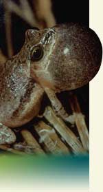
Calling Frog Survey: Monitors Instructions
Before the Survey…
Learning:
Attend a workshop to learn the frog and toad species of the area, their calls, and the monitoring procedure. Workshops are offered in most Chicago Wilderness counties, in February. Plan to attend a workshop each year that you monitor in order to brush up on your skills and learn of other amphibian or reptile monitoring projects that are happening.
Make a commitment to learn the frog and toad calls before the first survey. It is acceptable to bring a tape or disk of the calls to help you identify what you hear, as long as it is played softly, or is played in the car, so that you do not encourage the real frogs to call.
For active monitors, compact disc recordings of Chicago Wilderness frog calls are available free of charge. If you do not already have a CD and do not receive one at a workshop, please contact Jamie Forberg.
You can also download the calls of the native species from Calling Frog Survey: Chicagoland Frogs, and record them on a cassette or disk.
You may wish to download a copy of the monitoring protocol as well.
Establishing a Monitoring Route:
If you are a returning monitor, it is best for you to continue monitoring the same sites, or routes, as last year. Feel free to add new routes to your list if you want to do more.
For those who need to establish a new monitoring route, the workshops are the place to do so. Experts familiar with your area will be present at the workshops to help. They can suggest sites that are of high priority for scientific or land management reasons. You also may monitor a wetland or water body of particular interest to you.
Frogs and toads breed in ponds, swamps, lakes, etc., with a preference for temporary or semi-permanent waters. Although a temporary water body that usually dries up in a few months may appear to be a poor choice for breeding, it may in fact be an excellent choice because of the absence of tadpole predators such as fish.
Within your monitoring route(s), we recommend that you pick five listening points, or locations, for monitoring. This will require one or two hours of your time on each night you monitor. If you choose more than five locations (listening points) you may not be able to sustain the effort in the future. However, the number of locations you choose is up to you—more or fewer than five is ok, if it works for you. It is important that you choose locations that are at least 200 meters apart. If possible, try to include several habitat types (for example, a temporary woodland pond, or a marsh, or a shallow area of a lake) on your route.
Each land agency has it own procedures for allowing us night access to the preserves. You can learn the procedures by attending the workshop within the appropriate county.
| Terminology - Route vs. Location: Remember that we are using the term route to describe your overall site, or your entire monitoring area. We are using the term location to describe the individual listening points within each route. You will likely have several locations within your route. (You may certainly choose more than one route, each containing several locations). |
Roadside Monitoring:
In rural, mixed suburban-rural, and even some forest preserve areas it is possible to establish a route by driving down roads and spotting bodies of water, which are often less than a mile apart. The route you explore should have as little automobile traffic as possible so you have a good chance of hearing breeding calls later when you are monitoring. If you can safely park your car at or near a water body at night, you can monitor it. Pick a location (listening point) where you can listen for calls each time you monitor. That spot should be no more than 100-200 feet from the water in order to be able to hear weaker mating calls (eg., from leopard frogs). If you must leave the roadside in order to get to the listening point, it is essential that you obtain advance permission of the landowner..
Routes in Completely Developed Areas:
In completely developed urban or suburban areas it is unlikely that you will be able to establish a roadside route. Although there are scattered stormwater retention ponds, corporate estate ponds, lawn ponds decorating newer subdivisions, and ponds or lagoons in city parks, most of the appropriate water bodies will be found in the forest preserves. It is best to use maps to locate water bodies within these heavily developed areas.
Finding the GPS coordinates for each of the locations (listening points):
When you record your data, you'll need to write down the GPS coordinates for each monitoring location. The two best ways to do this are to use a hand held GPS unit or to estimate the coordinates using one of several internet sites that we discuss below.
| Note: Enter the GPS coordinates as positive numbers. Our longitude is negative, but we include the oW label to designate this. |
If you don't have a GPS unit, you can find the coordinates by moving the marker on the map on the Locations page in the data entry website. You may also visit this website: http://www.google.com/maps?t=k.
- Click on "Get Directions" in the upper left of the Google screen. In the box labeled "A", type in your address or some other address that will get you to the Chicago region.
- Click on button titled "Get Directions." A thumbtack labeled "A" should appear on the map.
- Drag the "A" thumbtack to a new location, and its GPS coordinates should appear in box "A" in the upper left.
Other websites such as Google Earth also can find GPS coordinates for you. Please use decimal degree format if you are offered a choice – this looks like 44.4444, for example.
You may also include a very detailed map of your locations if you are submitting handwritten data, and the person entering the data will find the GPS coordinates. However, it is highly preferred that you conduct this step yourself if at all possible.

Conducting the Survey…
Suitable Weather Conditions:
When suitable weather conditions for monitoring have arrived, time your arrival at the first location (listening point) so you can begin monitoring one half hour after sunset.
Suitable weather conditions for amphibians will generally be weather conditions deemed to be marginally suitable for humans. These include periods following a rain or periods of high humidity. Warmer days are good times for monitoring, especially in early spring. A Facebook Group, The Calling Frog Survey, is a good way to know if the weather conditions are right, so this can be a good way to judge when to go out.
| Guidelines for Suitable Monitoring Weather | |
| Period | Minimum Air Temperature (degrees Fahrenheit) |
| March 15 - April 20 | 45° |
| May 10 - May 30 | 55° |
| June 20 - July 10 | 65° |
Note that these are guidelines. If the air temperature is a few degrees below the guidelines and the frogs appear to be actively chorusing, go ahead anyway. We have to make our decision on when to monitor on the basis of a weather forecast. However, the male amphibians may be stimulated to call on the basis of the water temperature. Once the sun has set, the air cools more rapidly than the water, and the frogs may still be responding to the heat of the afternoon. For this reason, air temperature is probably not the best indicator of calling activity. But measuring water temperature is something that can only be done upon arrival; and sometimes can't be done at all if there is no access to the shoreline. If air temperature is not approaching the minimum suggested temperature, wait until it does, even if it is past the recommended date.
Beaufort Wind Scale:
Monitoring should not be conducted when the Beaufort wind scale exceeds 3. Strong winds will affect your ability to hear the calls of frogs and toads.
| Beaufort Wind Scale | Wind Speed (mph) | Description | |
| 0 | <1 | CALM: | smoke rises vertically |
| 1 | 1-3 | LIGHT AIR: | rising smoke drifts, weather vane inactive |
| 2 | 4-7 | LIGHT BREEZE: | leaves rustle, can feel wind on face |
| 3 | 8-12 | GENTLE BREEZE: | leaves and twigs in constant motion, small flags extend |
| 4 | 13-18 | MODERATE BREEZE: | moves small branches, raises dust and loose paper (too windy to monitor) |
| 5 | 19-24 | FRESH BREEZE: | small trees in leaf begin to sway (way too windy to monitor) |
Other Preparations:
Be sure that you are following any required access procedures. These vary from county to county. You will learn of any required procedures at the training workshops.
Bring the appropriate equipment—data sheets, rubber boots or old shoes, rain gear, camera (optional), audio recorder & blank cassette tape (optional; do not play tapes to stimulate calling), thermometer, pencils (more than one!), flashlight, GPS unit (optional), permit (if required in your county). If you are entering forest preserve land, a whistle (in case you and your partner become separated) and a cell phone are important aids.
Since you will be conducting these surveys in the dark, you are encouraged to bring an assistant along to share in the experience. This person can help you find the sites, document some kinds of information, and substitute for you in case of an illness.
Recording Weather Data:
The Data Sheet provides blank spaces for all of the necessary data:
At each location (listening point) record the wind strength using the Beaufort wind scale.
At each location, record the time and measure air temperature at ground level.
At each location, record the percent cloud cover.
While you are waiting to record the temperature, note the appropriate Weather Bureau Sky Code.
Note that if conditions do not change during the evening, you may use your initial wind scale, cloud cover, and Sky Code estimates for all locations, rather than taking the time to re-estimate at each location.
Weather history within the past 48 hours (rain and temperatures- above freezing or below freezing) should also be recorded.
| Weather Bureau Sky Code | |
| CODE | DESCRIPTION |
| 0 | Few clouds |
| 1 | Partly cloudy (scattered) or variable sky |
| 2 | Cloudy (broken) or overcast |
| 4 | Fog or smoke |
| 5 | Drizzle |
| 7 | Snow |
| 8 | Showers |
Recording Optional Data:
Optional additional information to note at each location: A general evaluation of water level in the wetland at the time of the survey (if possible). Any major changes to the breeding site since the previous survey. Any major changes to the habitats adjacent to the monitoring location since the previous survey.
Listening for Calls:
Listen at each station for five minutes and record the Call Index (call intensity) for each species on the data sheet. If noise from traffic or other sources interferes with listening, extend the listening period for another five minutes.
| Call Index Definitions | |
| 1 | Individual calls can be counted; there is space between calls. |
| 2 | Some calls are overlapping; but individuals are still distinguishable. |
| 3 | Chorus is constant, continuous and overlapping; impossible to count individuals. |
| OB | Indicates a species was seen (observed), but not heard during the survey. |
Difficult Species to Identify:
Scientists involved with this project recommend that we report the two gray tree frog species generically as "gray tree frog" because of the known difficulty in distinguishing their calls. Volunteers are urged to tape the tree frog calls and send them to their county coordinator or the Habitat Project for further identification. It is very important to include the air temperature (and water temperature if possible) when submitting a tape. This will help scientists determine which tree frog species you have recorded.
A number of other species are of special concern because of their rarity. If you think you have heard wood frogs, Fowler’s toad, cricket frogs, pickerel frogs orPlains leopard frogs you are urged to tape the calls or take a photograph and submit as outlined above. Also, call your County Coordinator or the Calling Frog Survey and post your observation on the facebook group: The Calling Frog Survey right away in order to give the scientists an opportunity to visit the site during breeding activity.
Note: Any time that documentation of a species is made by photos or audio recordings, please denote under the "Comments" section of the datasheet.
After the Survey…
Entering data:
The deadline for entering your data is July 31. Please do not forget to enter or send in your data—we can’t use it if we don’t have it!
The best way for you to enter your data is to use our interactive database. If you do not already have a login name and password, contact the PNNM (773-755-5164) or your county coordinator to get one. This site is easy to use, but first-time users sometimes encounter some idiosyncracies that foil their data entry attempts. If you encounter difficulties with the site, please do not hesitate to call the PNNM for help! We can quickly get you back on track and alleviate possible frustration.
When you enter or send in your results, it is important to describe the route in a manner that will allow others to know precisely where your locations (listening points) are located and where the wetland is in relation to the location. The best way to do that is to describe your walking route and provide GPS coordinates for each location. It is very helpful to indicate landmarks, such as road intersections, streams, bends in roads, or buildings, and include their relations to the listening points.
Indicate the type of wetland; for example, is it a vernal pool (ie temporary), a pond in a wood lot, a marsh, a bog, a fen, a creek, a slough, a farm pond, a retention pond, a city park pond, etc.
We recommend that you draw a map of your entire route for your own use in getting from one stop to the next.
Very Important Final Notes:
 Do NOT harass, take, or move
any animals while monitoring. It is important to disturb the
area as little as possible and to be aware that taking animals
from forest preserves without a permit is punishable by law. Do NOT harass, take, or move
any animals while monitoring. It is important to disturb the
area as little as possible and to be aware that taking animals
from forest preserves without a permit is punishable by law. |
Please report any illegal activity related to rare animal or plant taking to your county coordinator or to the PNNM at 773-755-5164.
| County Coordinators | |||
| Illinois Counties | |||
| Cook County, IL | |||
|
Cindy Duda | 773-631-1790 x16 | cynthiaduda@cookcountyil.gov |
|
Laura Milkert | 312-665-7444 | lmilkert@fieldmuseum.org |
|
Susan Fargo | 773-883-7275 | sfargo@lincolnparkconservancy.org |
| DuPage County, IL | Cindy Hedges | 630-876-5929 | chedges@dupageforest.com |
| Kane County, IL | Pam Otto | 630-513-4346 | potto@stcparks.org |
| Kendall County, IL | Jody Strohm | 630-553-4025 | JStrohm@co.kendall.il.us |
| Lake County, IL | Gary Glowacki | 847-968-3264 | gglowacki@lcfpd.org |
| Ellen T. McKnight | eltmck@gmail.com | ||
| McHenry County, IL | Sara Denham | 815-728-8307 | Sdenham@mccdistrict.org |
| Will County, IL | Glen Buckner | 815-722-9881 | gbuckner@fpdwc.org |
| Jason Buss | 815.722.8191 | jbuss@fpdwc.org | |
| Indiana Counties | |||
| Lake, Porter, LaPorte, IN | Jim Erdelac | 219-879-4725 | volunteer@heinzetrust.org |
| Newton, Jasper, IN | Bob Brodman | 219-866-6215 | bobb@saintjoe.edu |
Any Questions??
Please don't hesitate to contact Jamie Forberg or your county coordinator with any questions you have. Or pose your question to the internet Facebook Group, The Calling Frog Survey.
Thanks for your help in conducting this survey and have an enjoyable field season!